|
|
||||||
Area units: Data units: |
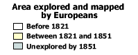 |
Area explored and mapped by Europeans |
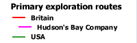 |
Primary exploration routes |
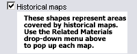 |
This layer shows black outline shapes on the map which represent the approximate areas covered by selected historical maps from the time period. These maps were used in the compilation of "Area explored and mapped by Europeans ". The shapes may be rectangular or distorted depending on the accuracy of the original map, as well as its map projection. The name of the cartographer and the date the original map was published are shown in the upper left corner of the map area. Use the Related Materials drop-down menu in the topbar above the map to choose one of these maps from the list. This will pop up a new window showing a redrawn version of the map you have chosen, as well as a reproduction of the original. |
|
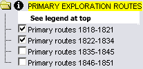
This folder contains layers showing primary exploration routes for the time periods listed. The layers can be viewed individually or together. The combined PRIMARY EXPLORATION ROUTES is the active layer. See explanation in Active Tools below. |
| This folder contains layers viewable for reference purposes. | |
| This layer shows a selection of rivers and lakes in addition to the major features shown by default. | |
 |
This layer shows current Canadian provincial and territorial boundaries, as well as selected cities. |
 |
Zoom In: Zoom in to see more detail. Labels appear for exploration routes (showing explorer's last name(s) and the date of the exploration) and selected islands, peninsulas, rivers and waterbodies. |
| The active layers in this map are in the Primary Exploration Routes folder. Use the tools below to get data about the exploration routes in these layers. | |
Identify: Click on the Identify tool, then click on the map on one of the exploration routes, to pop up a box showing the explorer's name and date. |
|
Table: Click on the Table tool, then click or drag a rectangle on the map across one or more exploration routes, to select routes and pop up a table showing information about the selected routes. See Table Fields below. |
|
| Query: Click on the Query tool, to pop up a Query box. Use the input boxes to specify selection criteria and click "Submit query" to select routes and pop up a table showing information about the selected routes. See Table Fields below. |
| Explorer | Full name of the explorer(s). |
| Dates | The year(s) in which the exploration took place. |
| Country | The country of origin of the exploration. |
| Purpose of sponsor | Exploration occurred for many purposes, and any journey usually had more than one: the search for new trade routes, the expansion of colonial territories, the pursuit of wealth, or a combination of military, missionary or scientific reasons, were often involved. This field identifies the main purpose or sponsor of an expedition; when unspecified the general term "Exploration" is used. |