|
|
||||||
Area units: Data units: |
 |
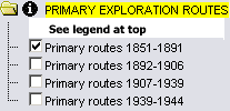
Primary exploration routes |
Selected settlements which were present during the time-period are shown. |
|
|
This folder contains layers showing primary exploration routes for the time periods listed. Winter camps are also shown for explorations during the middle two time-periods. All layers in this folder can be viewed individually or together. The combined PRIMARY EXPLORATION ROUTES is the active layer. See explanation in Active Tools below. |
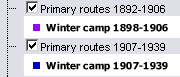 |
The Primary routes 1892-1906, and Primary routes 1907-1939 layers contain not only the exploration routes, but also the locations of winter camps. On the map, the camps (where vessels were anchored and crews waited until the ice was broken up enough to sail again) are also labeled with the date when the winter camp occured and the letters WC. |
| This folder contains layers viewable for reference purposes. | |
 |
This layer shows current Canadian provincial and territorial boundaries, as well as selected cities. |
 |
Zoom In: Zoom in to see more detail. Labels appear for exploration routes (showing explorer's last name(s) and the date of the exploration) and selected peninsulas, capes and points. |
| The active layers in this map are in the PRIMARY EXPLORATION ROUTES folder. Use the tools below to get data about the exploration routes in these layers. | |
Identify: Click on the Identify tool, then click on the map on one of the exploration routes, to pop up a box showing the explorer's name and date. |
|
Table: Click on the Table tool, then click or drag a rectangle on the map across one or more exploration routes, to select routes and pop up a table showing information about the selected routes. See Table Fields below. |
|
| Query: Click on the Query tool, to pop up a Query box. Use the input boxes to specify selection criteria and click "Submit query" to select routes and pop up a table showing information about the selected routes. See Table Fields below. |
| Explorer | Full name of the explorer(s). |
| Dates | The year(s) in which the exploration took place. |
| Country | The country of origin of the exploration. |
| Purpose or sponsor | Exploration occurred for many purposes, and any journey usually had more than one: the search for new trade routes, the expansion of colonial territories, the pursuit of wealth, or a combination of military, missionary or scientific reasons, were often involved. This field identifies the main purpose or sponsor of an expedition; when unspecified the general term "Exploration" is used. |