|
|
||||||
Area units: Data units: |
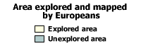 |
Area explored and mapped by Europeans |
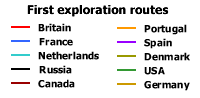 |
First exploration routes |
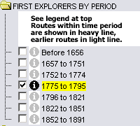 |
This folder contains layers showing expedition routes for the groups and time periods listed. Turning one layer on in this folder will turn all other layers off. Each layer in the FIRST EXPLORERS BY PERIOD folder is an active layer.
See explanation in Active Tools below. The explored area shown in each layer represents the area which had been explored and mapped by the end of the time period. |
|
This folder contains two layers showing all exploration routes, symbolized in two different ways. |
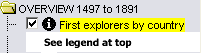
| This layer shows all of the first exploration routes, coloured according to their country of origin. This is one of the active layers. See explanation in Active Tools below. | |
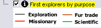 |
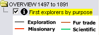
This layer shows all of the first exploration routes, coloured according to the primary purpose of the exploration (not according to the main legend above). As noted in the Table Fields section below, most explorations had many purposes. The purpose shown on this layer is the primary purpose. This is one of the active layers. See explanation in Active Tools - First explorers by purpose below. |
| This folder contains layers viewable for reference purposes. | |
| This layer shows a selection of rivers and lakes in addition to the major features shown by default. | |
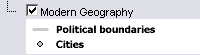 |
This layer shows current Canadian provincial and territorial boundaries, as well as selected cities. |
 |
Zoom In: Zoom in to see more detail. Labels appear for exploration routes (showing explorer's last name(s) and the date of the exploration) and selected rivers and waterbodies. |
| Query: Click on the Query tool, to pop up a Query box. Use the input boxes to specify selection criteria and click "Submit query" to select routes and pop up a table showing information about the selected routes. See Table Fields below. | |
|
Each layer in this folder is an active layer. Only the thick lined exploration routes (representing the exploration during the time-period listed) are active, and therefore, you cannot select the thin lined routes. Use the tools below to get data about the exploration routes in these layers. To get information about all routes simultaneously, click on the First explorers by country layer in the SUMMARY VIEWS 1497 to 1891 folder. |
Identify: With one of the above layers on, click on the Identify tool, then click on the map on one of the exploration routes, to pop up a box showing the explorer's name and date. |
|
Table: With one of the above layers on, click on the Table tool, then click or drag a rectangle on the map across one or more exploration routes, to select routes and pop up a table showing information about the selected routes. See Table Fields below. |
|
 |
Clicking this layer on makes it the active layer. Use the tools below to get data about the exploration routes in these layers. |
Identify: With this layer turned on, click on the Identify tool, then click on the map on one of the exploration routes, to pop up a box showing the explorer's name and date. |
|
Table: Click on the Table tool, then click or drag a rectangle on the map across one or more exploration routes, to select routes and pop up a table showing information about the selected routes. See Table Fields below. |
|
 |
Clicking on this layer makes it the active layer. Use the tools below to get data about the exploration routes in these layers. |
Identify: With this layer turned on, click on the Identify tool, then click on the map on one of the exploration routes, to pop up a box showing the explorer's name and date. |
|
Table: Click on the Table tool, then click or drag a rectangle on the map across one or more exploration routes, to select routes and pop up a table showing information about the selected routes. See Table Fields below. |
| Explorer | Full name of the explorer(s). |
| Dates | The year(s) in which the exploration took place. |
| Country | The country of origin of the exploration. |
| Explorer | Full name of the explorer(s). |
| Dates | The year(s) in which the exploration took place. |
| Country | The country of origin of the exploration. |
| Explorer | Full name of the explorer(s). |
| Dates | The year(s) in which the exploration took place. |
| Purpose of exploration | Exploration occurred for many purposes, and any journey usually had more than one: the search for new trade routes, the expansion of colonial territories, the pursuit of wealth, or a combination of military, missionary or scientific reasons, were often involved. This field identifies the main purpose of an expedition (with the sponsor sometimes listed in brackets); when unspecified the general term "General exploration" is used. Acronyms for sponsors are described below: |