|
|
||||||
Area units: Data units: |
Reserves shown as points |
|
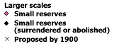 |
Larger scales |
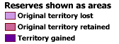 |
Reserves shown as areas |
| Metis Children's Land Grant The Métis Children's Land Grant is not a reserve under the reserve system, and is included as in addition to the reserve information. The land grant was divided and distributed among the Métis of Manitoba. Mostly granted and approved in the 1870s and 1880s, their allotments were sold to white settlers before the Métis left for lands further west. | |
| Surrendered islands Islands in southern Ontario traditionally occupied by native people, surrendered mainly in the 1850s. | |
| Band areas in BC As a result of the large number and small size of native reserves in British Columbia, bands as well as individual reserves, are identified on the map. a band is recognized by the government as a group of native people for whom the government has set aside lands, including reserves, for their common use or benefit. British Columbia bands and reserves are shown ca 1900; territorial changes are not indicated. |
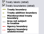 |
Treaty labels (detail), and Treaty boundaries (detail) are only visible at large (zoomed in) scales. To see these layers, click in their checkboxs, then zoom in until the Note that the boundaries for Treaty No.8 (1899) are shown, but the reserves within this treaty area are not included on this map. |
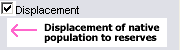 |
Displacement of native peoples to reserves. The beginning of the arrow shows the general area from which native people were displaced. |
| This layer contains labels for major rivers and lakes. | |
 |
This layer shows all of the reserves across Canada coloured according to the Linguistic family to which the dominant population of that reserve belongs. In some cases, native people of different linguistic families live on a single reserve, however, the dominant linguistic family determines the colour chosen to represent that reserve. Where there is more than one ethno-linguistic group within one reserve, the groups are each listed in the Ethno-linguistic group field of the reserves table. Use the identify (data) tool to pop-up this information for any reserve on the map. |
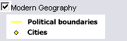 |
Provincial and territorial boundaries for 2006, as well as selected modern cities. |
|
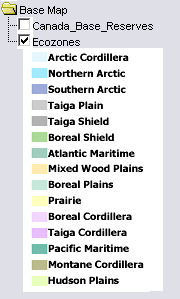
The default basemap is the Canada Base Reserves layer. It is simply an olive green background colour for all of Canada. The Ecozones layer shows the ecozones across Canada. One of these layers is always on, so turning one on, turns the other off. |
| Zoom in: Zoom in to see more detailed reserve boundaries and information. (see Map Tips below). Some other layers are also only visible when zoomed in: Treaty labels (detailed), Treaty boundaries (detailed), and Displacement. | |
| Active layer: The reserve information is always the active layer. Use the tools below to get information about native reserves in 1902. | |
| Identify: Click on this tool, then click on the map to popup the name of any reserve. | |
Table: Click on this tool, then click or drag on the map to select reserves, and popup a detailed table data for those selected reserves. See Table Fields below for description of fields in this table. |
| Region | In eastern provinces where there were no treaties, the province is listed. In parts of Ontario, and all locations west of Ontario (except BC), the province and the treaty names are listed (treaty names in brackets). In BC, province name is followed by the agency name in brackets. |
| Reserve No | All numbered reserves (including those with upper-case letters) listed are official reserve numbers. Lower case letters (a - n) indicate land other than reserve, or reserve that had been surrendered before the adoption of the official numbering system (i.e. they are unofficial, and used only for map identification). |
| Reserve/Band Name | The first name listed is the original name. Names in ( ) brackets are synonyms or former names, and names in [ ] brackets are contemporary names. In British Columbia, this field denotes the band (not the reserve) name, sometimes followed by the name of a subgroup (also called a band). A Band is recognized by the government as a group of native people for whom the government has set aside lands, including reserves, for their common use or benefit. |
| Date Est. | Year of the initial grant (or first data available) for all places outside of BC. Year of the initial allotment of land in British Columbia. |
| Ethno-Linguistic Group | Ethno-linguistic group, or groups. |
| Linguistic Family | Linguistic family of the dominant ethno-linguistic group on the reserve. |
| Original Area (ha) | Area in hectares initially cited for reserve or granted land. All area units have been converted to hectares for consistency. |
| At surrender (ha) | Area in hectares of reserve at time of surrender (if surrendered). |
| Area 1902 (ha) | Area in hectares remaining in 1902. (Hectares in 1902, Acres in 1902) |
| Notes | This field holds descriptive information for selected reserves. |
| Other Codes: | n.d. - no date available n.s. - not surveyed n.a. - no acreage available |
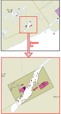 |
Extra detailed maps of selected reserves, when Zoomed in. At the full view (all of Canada) reserves appear only as points, but as you zoom in, their outlines become visible. Some reserves are shown in great detail if you zoom in to a large scale.There is a selected group of reserves across the country which will appear in even more detail as you zoom in. The illustration to the left illustrates what you will see if the reserve you zoom in on has this extra detail. There will be a black outline around the area of detail, and inside the outline, the reserve boundaries and lake shorelines will be significantly more detailed. In the example in this illustration, not only do you see more detail within the reserve shapes, but you will also see other reserve areas that are too small to see at smaller scales (note the island in the detail map which does not appear in the less detailed map above). |
|
Native Reserves - British Columbia, 1902 Native Reserves - The Prairies, 1902 Native Reserves - The East, 1902 |