|
|
||||||
Area units:
Data units:
|
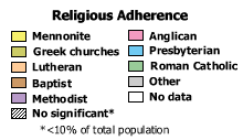 |
Religious adherence : |
 |
Area outlines |
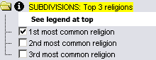 |
The three layers shown here (1st, 2nd and 3rd most common religion) can be viewed individually by clicking on their respective checkboxes. Turning one layer on, will turn the others off so that you can view only one of the rankings at a time. "Most common" is based on the number of adherents per religion by census subdivision, city or town, or grouped Native reserve, as recorded in the census records for 1921. |
| SUBDIVISIONS: Top 3 religions is always the active layer. Use the tools below to get data about the three most common religions. | |
Identify: Click anywhere within a census subdivision, city or town, or grouped Native Reserve to get the name of that area. If there is a number in front of the name, it is a census subdivision. If there is no number, it is a city or town. If it is a Native reserve, it will simply say Native reserves |
|
| Table: Click or drag a rectangle to select any of the areas. A table pops up showing: the name of the province or city, the numbers of people of various ethnic origins, and the total number of people. See Table Fields below. |
| Census subdivision | Name of the geographic unit, either a census subdivision (beginning with a number), grouped Indian Reserves (grouped by census subdivision), a city or a town (name listed without a number) |
| 1st, 2nd, 3rd Religion | The name of the 1st, 2nd and 3rd most common religion in 1921 in that census subdivision |
| 1st, 2nd, 3rd Number | The total population adhering to the corresponding religion in 1921 in that census subdivision |
| 1st, 2nd, 3rd Percent | The percent of the total population adhering to the corresponding religion in 1921 in that census subdivision |
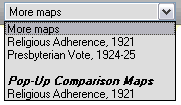 |
Pop-up Comparison Maps |