|
|
||||||
Area units: Data units: |
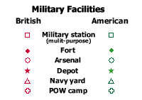 |
Military Facilities |
Main Communication Links |
|
 |
Settlements and travel corridors shown are those which existed between 1812 and 1814. |
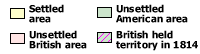 |
Settled area represents the "ecumene" or area of generalized continuous settlement as it existed between 1812 and 1814. Unsettled areas are shown as British, American, or British held territory (areas claimed by the United States, but occupied by the British in 1814). |
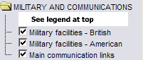 |
This folder contains the primary military information contained within this map (see Legend Description above for description of symbols). Click check boxes to turn individual layers on and off. |
|
This layer shows the locations where British naval raids took place. |
|
This layer shows the locations of First Nations (Indian) villages between 1812 and 1814 |
| The map on logistics for the War of 1812 attempts to illustrate the overwhelming superiority of the 'internal' supply lines of the American armies over the 'external' supply lines of the British armies. The United States had a relatively large population (over 7 000 000), and its national strength in terms of manpower, commerce, manufacturing, and agricultural output was more than 12 times that of the provinces of British North America (BNA). Transportation routes on rivers, roads, seas, and lakes were denser and provided shorter, and thus quicker, lines of communication and supply for the Americans. However, as the British naval blockade tightened during the war, various land and water routes were severely disrupted. Chesapeake Bay, in particular, was for a time completely cut off. The British transatlantic communication and supply routes were open to attack on the ocean, and were particularly vulnerable along the St Lawrence waterway. Moreover, break-of-bulk points at Quebec, Fort William Henry, Montreal, Kingston, and York meant long delays in transshipment. Men and supplies were transferred from ocean going ships to schooners, bateaux, Durham boats, or cargo canoes for river or lake transport, or to wagons for overland travel. On the average rates of travel in BNA were slower than in the United States. The relatively small population of the Maritimes and the Canadas(fewer than 500 000)meant extremely limited resources of food, fodder, and transportation for the British commissariat. Thus, most supplies had to be shipped across the Atlantic or obtained from the United States. Smuggled food (largely cattle) and ammunition from the New England states, which had opposed the war from the start, became a major source of supply for the British. |