|
|
||||||
Area units: Data units: |
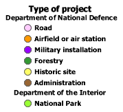 |
Type of project |
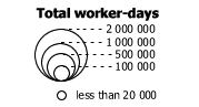 |
Total worker-days |
 |
Settlement |
 |
Clicking this checkbox turns the visibility of the circles representing work camps on and off. Clicking on the label icon |
| Clicking the checkbox beside the word TRANSPORTATION will make visible on the map, both the Major railway and the Major road layers. Each of these sublayers can be turned on and off individually. | |
| Clicking the checkbox will turn the labels for the provinces on and off. | |
 |
Modern Geography ( current provincial and territorial boundaries, as well as selected cities) is available for reference. |
| Zoom in: Labels for the work camps are only visible when zoomed in. If the label icon beside the WORK CAMPS layer is turned on ( |
|
| When the check box beside the WORK CAMPS layer is checked, it is the active layer, and you can use the tools below to get data about this layer. | |
Identify: Click on this tool, then click on any of the work camp circles on the map, to learn how many person-days was worked at that camp between 1932-1936. |
|
| Table: Click on any one of the work camp circles, or click and drag across the map to select a group of work camps to learn more about each work camp. See table fields below for a description of the information available. |
| Province | Province in which the work camp is located. |
| Location | Name of the city, town or works project. |
| Project type | The type of project. Note: all projects were administered by the Department of National Defence, except the National Park projects which were administered by the Department of the Interior. |
| Person-days | The total number of person/days for the duration of the project |
| Direct relief, formerly a public charity granted to the chronically poor, was extended in the Depression to those whose distress was caused solely by unemployment. Relief works were deliberately labour-intensive and mainly concerned with municipal projects such as the construction of water mains, sewers, and roads. Agricultural aid provided seed, feed, and fodder and sought to re-establish farmers. Although most dominion funds were administered through provincial-municipal agencies, federal departments, especially Defence and Agriculture, directly funded programs such as work camps and projects under the Prairie Farm Rehabilitation Act. |