|
|
||||||
Area units: Data units: |
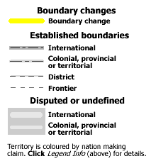 |
Boundaries |
 |
Territorial control (1670-1866) |
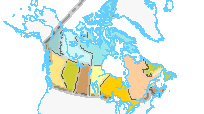 |
Territorial control (1867-2001) |
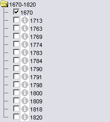 |
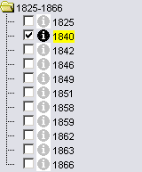
1670-1820; 1821-1866; 1867-1898; 1901-1999 The four folders with the date ranges above contain a series of layers - each one representing a snapshot of what the political boundaries of northern North America looked like at that time. To view any one of the layers simply click in the checkbox beside the layer's name. For each layer other than 1670, some of the boundaries are highlighted by a thick yellow line. These highlighted boundaries represent a change in the nature or location of that boundary since the previous year listed. Clicking the checkbox will also make that layer active, see Active Tools below to learn how to get information from a layer when it is active. |
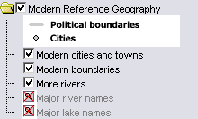 |
Modern refernece geography |
 |
Zoom in: All layers are visible at all scales, with the exception of the Major river and Major lake name layers, which are only visible at large scales. In order to view these layers, click on the zoom in button, then click or drag a rectangle on the map to zoom in to a scale where they become visible. |
 |
Clicking in the checkbox beside any layer will turn that layer's visibility on, it will also make that layer active (represented by the black |
Identify: Click on this button, then click on one of the boundaries highlighted in yellow to pop-up a description of the change which that particular boundary had undergone since the previous year listed. |
|
| Table: Click on this button, then click on one of the boundaries highlighted in yellow or drag a box over several of the boundaries to select the boundary changes you want more information about. A table will pop-up with information about the boundaries selected. See Table Fields below. |
| Event | Short description of event and change. After 1867 these changes were primarily enacted by Acts of the Canadian federal parliament. |
| Year | Date of event. |
| Description | Full description of event and change, often including the legeslation which enacted the change. |