|
|
||||||
Area units: Data units: |
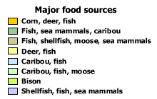 |
Major food sources |
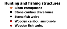 |
Hunting and fishing structures Symbols represent structures used in hunting and fishing for which archaeaological evidence has survived. Symbols show generalized distributions, rather than specific locations. |
| This layer shows major food source areas. This is the active layer. Click on the label icon |
|
| This layer shows hunting and fishing structures for which archaeaological evidence has survived. | |
 |
This layer shows modern geography (current provincial and territorial boundaries, as well as selected cities), and is available for reference. |
| This is the active layer. Use the identify tool below to get data about the features in this layer. | |
Identify: Click on the Identify tool, then click on the map on one of the areas, to pop up a box identifying the major food source for the area. |
Archaeological data permit only a partial picture of patterns of subsistence in late prehistoric Canada. |