|
|
||||||
Area units: Data units: |
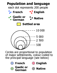 |
Population and language |
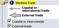
Maritime trade |
|
 |
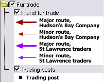
Fur trade |
 |
Inshore fishery |
 |
This folder contains layers showing population colour-coded for principal language; proportional circles for major settlements and dot distribution for rural areas. The layers can be viewed individually or together. |
|
This folder contains layers showing maritime trade routes; open arrows for external trade and solid gray arrows for coastal or intercolonial trade. The layers can be viewed individually or together. These are active layers. See explanation in Active Tools below. |
|
This folder contains layers showing fur trade routes and trading posts. The layers can be viewed individually or, most commonly, together. |
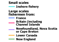
| This layer shows the active inshore fishery. At small scales these are consistently light blue (cyan) in colour. Zoomed in to larger scales these become colour-coded by the country of origin of the fishermen (see Legend Description above). | |
 |
This layer shows modern geography (current provincial and territorial boundaries, as well as selected cities), and is available for reference. |
 |
Zoom In: Zoom in to see more detail. Inshore fishery lines appear become colour-coded representing country of origin. |
| The active layers in this map are in the Maritime trade folder. Use the tools below to get data about the routes in these layers. | |
Identify: Click on the Identify tool, then click on the map on one of the route arrows, to pop up a box showing the Trade Goods carried in and out along this route. |
|
Table: Click on the Table tool, then click or drag a rectangle on the map across one or more route arrows, to select them and pop up a table showing information about the selected features. See Table Fields below. |
| Inbound | Description of trade goods inbound along this route. |
| Outbound | Description of trade goods outbound along this route. |
| The Newfoundland fisheries and the population of Saint-Pierre and Miquelon are shown before the outbreak of war between Britain and France in 1793. During the war the British occupied Saint-Pierre and Miquelon, evacuated the inhabitants, and disrupted the French fisheries in northern and western Newfoundland. the population of Newfoundland is shown for 1800. |