|
|
||||||
Area units: Data units: |
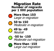 |
Migration Rate (class) |
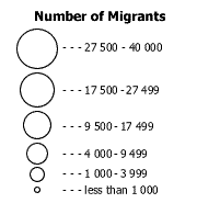 |
Number of Migrants |
 |
Settlement |
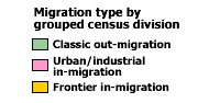 |
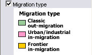
Migration type by grouped census division |
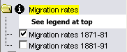 |
This folder contains Migration rates, for either the 1871-1881 OR the 1881-1891 decade; turning one layer on turns the other off. These are the active layers. See explanation in Active Tools below. |
|
This layer shows Migration type by grouped census division (see description above.) This layer is initially off and may be turned on, which colour-codes the settled area in each unit by type. |
|
This layer shows Modern Geography (current provincial and territorial boundaries, as well as selected cities), and is available for reference. |
|
The active layers in this map are in the Migration rates folder. Use the tools below to get data about the grouped CDs in these layers. |
Identify: Click on the Identify tool, then click on the map on one of the circles, to pop up a box showing the name of the grouped census division. |
|
Table: Click on the Table tool, then click or drag a rectangle on the map across one or more circles, to select grouped census divisions and pop up a table showing information about the selected units. See Table Fields below. |
|
| Query: Click on the Query tool, to pop up a Query box. Use the input boxes to specify numeric values as selection criteria for Migration rates, and click "Submit query" to select and pop up a table showing information about the selected grouped census divisions. See Table Fields below. |
| Grouped CD | 1881 grouped census division |
| Rate 1871-1881 | Number of migrants per 1000 population (negative numbers indicate out-migration, positive numbers indicate in-migration) |
| Rate 1881-1891 | Number of migrants per 1000 population (negative numbers indicate out-migration, positive numbers indicate in-migration) |
| Migration type | Dominant type of migration, over the two decade period covered by this map. |
|
Calculations based on the differences between expected and actual populations have been used to estimate intercensal net migrations by age and sex groups (see Authors and Sources page for details). |