|
|
||||||
Area units: Data units: |
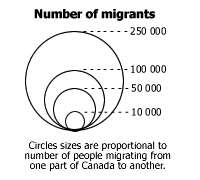 |
Number of migrants |
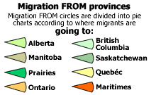 |
Migration FROM provinces |
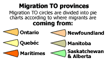 |
Migration TO provinces |
|
These layers show Migration FROM provinces as pie charts. This is an active layer. See explanation in Active Tools below. |
|
These layers show Migration TO provinces as pie charts. This is an active layer. See explanation in Active Tools below. |
|
This layer shows Settled area (ecumene) ca 1911, and is available for reference. |
 |
This layer shows Modern Geography (current provincial and territorial boundaries, as well as selected cities), and is available for reference. |
 |
This is an active layer, and to make it active you must click on the |
 |
This is an active layer, and to make it active you must click on the |
Identify: Click on the Identify tool, then click on the map on one of the provincial pie charts, to pop up a box showing the total migrants TO or FROM this province. |
|
Table: Click on the Table tool, then click or drag a rectangle on the map across one or more pie charts, to select and pop up a table showing information about the selected province(s). See Table Fields below. |
| Migration FROM | Province (or region) which migrants are coming from, going to all other provinces. |
| To MANITOBA, To SASKATCHEWAN, To ALBERTA, To BC, To PRAIRIES, To ONTARIO, To QUEBEC, To MARITIMES | Number of migrants going to all other provinces, from "MIGRATION FROM" province |
| Within EAST | Number of migrants going to all eastern provinces, from other eastern provinces listed. This duplicates migrants already listed above. |
| Total | Total number of migrants coming from "MIGRATION FROM" province to all other provinces |
| Migration TO | Province which migrants are going to, coming from all other provinces |
| From ONTARIO, From QUEBEC, From MARITIMES, From NEWFOUNDLAND, From MANITOBA, From ALTA/SASK | Number of migrants coming from all other provinces (or regions), to the "MIGRATION TO " province |
| Total | Total number of migrants going to "MIGRATION TO" province from all other provinces |
| The interprovincial movement of Canadian-born people was estimated directly from census data on province of birth, cross-tabulated with province of residence. For the Prairie Provinces the 1916 total of those born out of the province was derived from the census of that year. For other provinces the 1914 numbers were interpolated from the 1911 and 1921 censuses. The number of persons in each province of destination from each province of origin was compared with the 1891 number adjusted for survival over the 25-year period; the survival rates used were those from Bourbeau and Légaré (1982). |