|
|
||||||
|
Area units: Data units:
|
|
Locations of selected artwork |
|
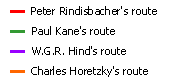 |
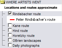
Where artists went - Routes |
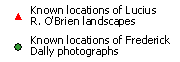 |
Where artists went - Locations |
|
Settled area (ecumene) ca 1891 |
|
|
Major rail lines ca 1891 |
| The layer showing the Locations of selected artworks is the active layer. See explanation in Active Tools below. | |
|
|
This folder contains layers showing WHERE ARTISTS WENT - Routes and Locations. The layers can be viewed individually or together. |
 |
This layer shows the names of the Provinces and Territories, ca 1889. |
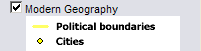 |
Modern Geography (current provincial and territorial boundaries, as well as selected cities) is available for reference. |
| This is the active layer, which remains active at all times. Use the tools below to get data about the site locations in this layer. | |
Identify: Click on the Identify tool, then click on the map on one of location symbols to pop up a web page showing the artwork created from that site. |
|
Table: Click on the Table tool, then click or drag a rectangle on the map across one or more location symbols, to select them and pop up a table showing information about the selected sites. See Table Fields below. |
| Artist | Name of painter or photographer |
| Title | Title or description of artwork |
| Medium | Medium of artwork |
| Date | Date of artwork |
| Click to pop up image | Click link to pop up web page of artwork |
| Locations of selected artworks and routes of artists are approximate as appropriate for scale of map. Settled area (ecumene) ca 1891 as shown is also a generalized approximation, shown to provide context. For more information about the artworks on this map, see individual web pages, as well as Authors and Sources and Authors' Special Notes. |