|
|
||||||
Area units: Data units: |
.gif) |
Spread of newspapers |
.gif) |
Key cities |
|
Towns with newspapers |
| The only political boundary on this map is the Canadian/American border, defined by the change in colour from olive to yellow. | |
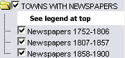 |
Clicking the TOWNS WITH NEWSPAPERS checkbox turns on all three Newspaper layers. Individual Newspaper layers representing the different date ranges can be turned on or off individually. |
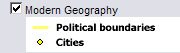 |
Modern Geography (current provincial and territorial boundaries, as well as selected cities) is available for reference. |
| Active layer: Clicking the checkbox makes the Spread of newspapers the active layer. Use the tools below to get information about the spread of newspapers. | |
Identify: Click anywhere on one of the regional spread arrows to display the story of the people who established a given province's first newspaper. |
|
| Table: Click or drag a rectangle to select any of the regional spread arrows. A table pops up showing information about that arrow. See Table Fields below. |
| Story of spread | The story of the people who established a given province's first newspaper. |
| Date | The date when the transplant occurred. |
.gif)