Maptour Page 7
Maptour: The Impact of the Great Depression, 1928-1940
The Dimensions and Timing of Relief


Click to enlarge

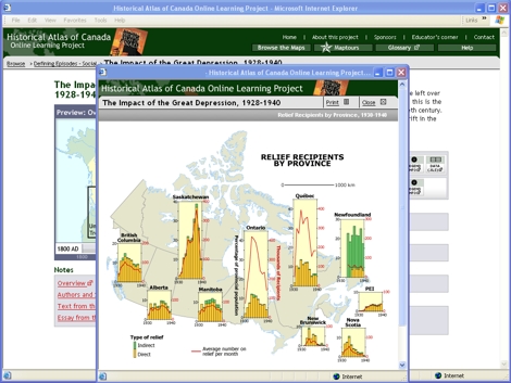
Map: Relief Recipients by Province, 1930-1940

Try This:

  • On the Browse topbar, click on "The Impact of the Great Depression, 1928-1940" to return to the chapter page. Then open the static map: "Relief Recipients by Province, 1930-1940."

Notice ...

  • The maximum number of welfare recipients in Saskatchewan and Ontario is similar (right scale, red line), but Ontario had four times the size, so welfare has only one-quarter the impact (left scale, yellow and green bars).
  • Relief in Ontario and Québec peaked early in the 1930s, whereas on the Prairies it reached at peak later in the decade.
  • The relief system in Newfoundland (not part of Canada in the 1930s) was very different from that found in Canada.

Consider!

  • Newfoundland demonstrates that the Depression was an international phenomenon.
  • An economic downturn hurts a dependent, urban society more suddenly than it does more self-sufficient, rural people.

Try This:

  • Click on the file under "Data Files (.xls)" if you wish to see the numbers upon which these graphs are based.

   These are just a few of the questions that these maps and data can address
If you have ideas for other questions, please use our Feedback page to send them in,
and they may be posted on the website in the future.