|
|
||||||
Area units: Data units: |
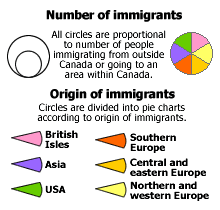 |
Number of immigrants/Origin of immigrants |
| This layer shows Immigration "TO" pie charts. This is the active layer. See explanation in Active Tools below. | |
|
This layer shows Immigration "FROM" pie charts. |
| This is the active layer. Use the tools below to get data about the features in this layer. | |
Identify: Click on the Identify tool, then click on the map on one of the "TO" pie charts, to pop up a box showing the Total number of immigrants represented by that chart. |
|
Table: Click on the Table tool, then click or drag a rectangle on the map across one or more of the "TO" pie charts, to select them and pop up a table showing numbers of immigrants coming from each area of origin. See Table Fields below. |
| Immigration to | Region, province, city or part of province receiving immigrants |
| British Isles, NW Europe, CE Europe, S Europe, Asia, USA | Number of immigrants coming from British Isles, Northern and Western Europe, Central and Eastern Europe, Southern Europe, Asia, and USA, respectively. |
| Total | Total number of immigrants coming to this area. |
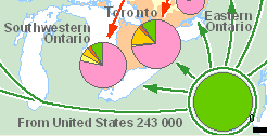 |
Pie charts change size when zooming in. |
|
The flows of immigrants shown on the map have been inferred from differences in the numbers of foreign born recorded in the censuses of 1901 and 1921. This excludes a great deal of re-migration. The numbers are lower than would be shown by the cumulated annual influx of immigrants. ‘Europeans' include many who came via the United States. See also Authors and Sources. |