|
|
||||||
1794 Treaty of London (Jay's Treaty): Established Saint-Croix River (NB) as boundary described in Treaty of Paris 1783, and started process of rectifying errors in boundary descriptions of the 1783 treaty.
1798 Prince Edward Island named
St. John's Island is renamed Prince Edward Island.
1803 USA buys Louisiana
In 1802 Spain cedes Louisiana to France, and by the Louisiana Purchase the following year, France sells it to the USA.
1809 Newfoundland regains lost territory
By the Labrador Act, Britain re-annexes the Labrador Coast and Anticosti Island to Newfoundland. These places had been assigned to the Colony of Québec in 1774.
1818 49th parallel becomes international boundary
Following the Treaty of Ghent in 1814, which provided for adjustments of boundary disputes arising out of the Treaty of Paris (1783), the international boundary between the USA and Rupert's Land is extended along 49th parallel from Lake of the Woods to the Rocky Mountains by Convention.
1818 Oregon Territory to be shared
The USA and Great Britain agree to jointly administer the Oregon Territory for 10 years.
1818 Oregon Territory redefined
By the Adams-Onis Treaty, the United States and Spain establish the southern boundary of Oregon Territory along the 42nd parallel. New Spain does not become Mexico until 1821.
1820 Nova Scotia gains Cape Breton
Cape Breton Island is re-annexed to Nova Scotia.
1821 Hudson's Bay Company gains North-western Territory
Great Britain establishes the Hudson's Bay Company as administrative authority in the North-Western Territory by the Act for regulating the Fur Trade and establishing a Criminal and Civil Jurisdiction within certain parts of North America.
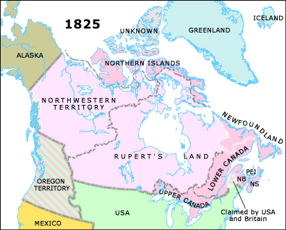
1825 Alaska boundary defined
The Anglo-Russian Treaty defines the lines of demarcation between Alaska and British North America.
1825 Lower Canada regains lost territory
By the Labrador Act, Anticosti Island and the Labrador Coast between Saint-Jean River and Anse Sablon are re-annexed to Lower Canada.