|
|
||||||
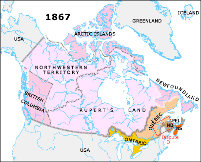
1851 Canada/New Brunswick boundary dispute resolved
Arbitrators achieve agreement on the location of the border between the colony of New Brunswick and the Province of Canada. An Act of Parliament officially resolves this dispute which had been going on since 1798, and which as recently as 1846 a British-appointed commission failed to settle (Dispute D: click dispute rectangle on map).
1858 British Columbia created
An Act of British Parliament to provide for the government of New Caledonia establishes new boundaries and the area is renamed British Columbia.
1859 Britain defines North-Western Territory
The Indian Territories Act establishes British jurisdiction over land not in Rupert's Land or British Columbia, officially naming this whole region The North-Western Territory.
1862 Stickeen Territory created
A British Order in Council creates the Stickeen (Stikine) Territory immediately north of British Columbia and south of the 62nd parallel.
1863 British Columbia enlarged
British legislation establishes the modern boundaries of British Columbia, excluding Vancouver Island. The portion of the Stickeen Territory of 1862 north of the 60th parallel is amalgamated back into the North-Western Territory.
1866 Vancouver Island joins British Columbia
British Columbia and Vancouver Island become one colony, called British Columbia.
1867 Canada established as federal state
The British North America Act unites the provinces of New Brunswick, Nova Scotia, and Canada into a federal state, the Dominion of Canada. It also renames Canada East and West to Québec and Ontario.