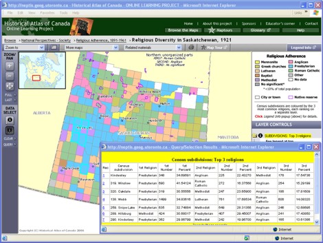
Maptour Page 5
Maptour: Religious Adherence, 1891-1961
Canada’s Census a Treasure Trove


Click to enlarge

Map: Religious Diversity in Saskatchewan, 1921

Try This:

  • Keep open the interactive map "Religious Diversity in Saskatchewan, 1921."
  • On the DATA SELECT toolbar, click on the Table tool and then click on any Census subdivision on the map to open a pop-up table of its information.

Notice ...

  • The table gives you the name of the census subdivision (the recording unit) and some statistical detail about its 3 most common religions.
  • The boundary of the census subdivision is highlighted. (You may have to drag aside the table box to see your chosen area.)

Try This:

  • With the Table tool still active, use the cursor to drag a rectangle on the map enclosing several Census subdivisions.

Notice ...

  • The table box re-loads, with a table naming all the Census subdivisions in your sample, and comparative statistical detail.
  • The boundaries of all the selected Census subdivisions are highlighted.

Consider!

  • Canada’s published decennial censuses are a remarkably rich resource, and the census manuscripts offer even more extensive detail.