|
|
||||||

1840 Province of Canada (West and East) created
By an Act of Union, Great Britain unites Upper Canada and Lower Canada into a single colony called the Province of Canada. For internal administrative purposes these regions are renamed, respectively, Canada West and Canada East.
1842 Maine boundary dispute resolved
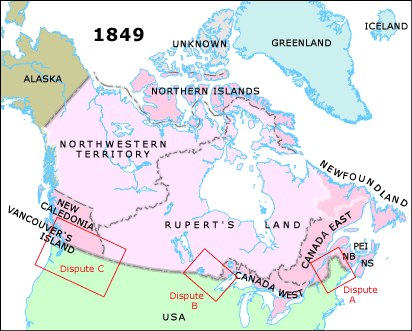
The Ashburton-Webster Treaty settles the international boundary between Britain and the USA (between Canada East and New Brunswick, and the states of Maine and New Hampshire; and between Canada West and the state of Minnesota.) These boundaries had remained undefined and in dispute since the Treaty of Paris in 1783 (Dispute A, Dispute B: click Dispute rectangle on map).
Previous attempts had been made towards rectifying the boundary between Canada East and New Brunswick, and the states of Maine and New Hampshire, by the Treaty of London (1794), and the Treaty of Ghent (1814). In 1831, through the Gallatin-Addington negotiation, The King of the Netherlands had even arbitrated a resolution, but this was not accepted by either Britain or the United States.
1842 Minnesota boundary dispute resolved
see above
1846 Oregon Territory divided
The Oregon Boundary Treaty extends the international boundary along the 49th Parallel to the Pacific, (excluding Vancouver's Island) dividing the Oregon Territory, which had been jointly administered by Britain and the USA since 1818, into two. The northern British area is called New Caledonia (Dispute C: click dispute rectangle on map).
1849 Vancouver's Island becomes a colony
Vancouver's Island is established as a Crown Colony.