|
Notice ...
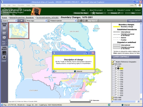
- The yellow lines highlight boundaries established or altered in 1713.
- A major international agreement between colonial powers has established
British control in some contentious areas, and created new conflict with France in others.
|
|
 |
Try This:
- On the DATA SELECT toolbar, click on the Identify tool and
then click on one of the highlighted lines on the map to
pop up its information.
|
|
|
Notice ...
- The Identify box contains a description of the boundary change.
(You can drag it aside if the map is obscured.)
|
|
 |
Consider!
- Resolving disputes between Britain and France call for the diplomacy
of a neutral power, in this case the Netherlands, so the treaty was signed
in the Dutch city of Utrecht.
- The stage is being set for the deportation of the Acadians. At another
time, see the chapter "Acadian Deportation and Return, 1750-1803."
|