Maptour Page 3
Maptour: The Acadian Expulsion: a Canadian Tragedy
A Half Century of Displacement


Click to enlarge

Map: Acadian Population Distribution: 1750, 1803

Try This:

  • Keep open the map "Acadian Population Distribution: 1750, 1803."
  • On the ZOOM/PAN toolbar, click on the "FULL" button to zoom out to the maximum area of the map.
  • Under LAYER CONTROLS, turn on the checkboxes for "POPULATION, 1750."

Notice ...

  • The label "Acadia" stretches across both French and British territory.
  • Acadian population is concentrated around the Bay of Fundy, Île Saint-Jean and Île Royale.

Try This:

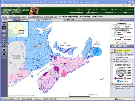
  • Under LAYER CONTROLS, turn on the checkbox for "ACADIAN POPULATION 1803."
  • Cycle back and forth between the checkboxes for "POPULATION, 1750" and "ACADIAN POPULATION 1803", the 1750 and 1803 maps, watching for changes in the places Acadians are living.
  • Then turn on the checkbox for "Population Comparison" as well.

Notice ...

  • Bar graphs show decreases in settled areas and increases in unsettled areas over the half century.

Consider!

  • The distribution of people has vastly changed over this half period.
  • This was an area of conflict and substantial civil disruption.